|
تضامنًا مع حق الشعب الفلسطيني |
ملف:Pan-European corridors.svg
اذهب إلى التنقل
اذهب إلى البحث

حجم معاينة PNG لذلك الملف ذي الامتداد SVG: 392 × 486 بكسل. الأبعاد الأخرى: 193 × 240 بكسل | 387 × 480 بكسل | 619 × 768 بكسل | 826 × 1٬024 بكسل | 1٬652 × 2٬048 بكسل.
الملف الأصلي (ملف SVG، أبعاده 392 × 486 بكسل، حجم الملف: 561 كيلوبايت)
| هذا ملف من ويكيميديا كومنز. معلومات من صفحة وصفه مبينة في الأسفل. كومنز مستودع ملفات ميديا ذو رخصة حرة. |
ملخص
| الوصف |
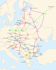
English: Map of the ten Pan-European transport corridors. |
| التاريخ | (UTC) |
| المصدر | |
| المؤلف |
|
| إصدارات أخرى |
|
| SVG منشأ الملف | .هذا الرسم المتجهي أُنشئ بواسطة Inkscape |


ترخيص
هذا الملفُّ مُرخَّص بموجب رخصة المشاع الإبداعي نسبة المُصنَّف إِلى مُؤَلِّفه - المشاركة بالمثل 3.0 العامة
- يحقُّ لك:
- مشاركة العمل – نسخ العمل وتوزيعه وبثُّه
- إعادة إنتاج العمل – تعديل العمل
- حسب الشروط التالية:
- نسب العمل إلى مُؤَلِّفه – يلزم نسب العمل إلى مُؤَلِّفه بشكل مناسب وتوفير رابط للرخصة وتحديد ما إذا أجريت تغييرات. بالإمكان القيام بذلك بأية طريقة معقولة، ولكن ليس بأية طريقة تشير إلى أن المرخِّص يوافقك على الاستعمال.
- الإلزام بترخيص المُشتقات بالمثل – إذا أعدت إنتاج المواد أو غيرت فيها، فيلزم أن تنشر مساهماتك المُشتقَّة عن الأصل تحت ترخيص الأصل نفسه أو تحت ترخيص مُتوافِقٍ معه.
سجلُّ الرَّفع الأصيل
This image is a derivative work of the following images:
- File:Blank_map_of_Europe_-_Atelier_graphique_colors.svg licensed with Cc-by-sa-2.5,2.0,1.0, Cc-by-sa-2.5,2.0,1.0/en, GFDL, GFDL/en
- 2008-09-23T18:46:08Z Antigoni 841x731 (498781 Bytes) Montenegro update
- 2007-09-16T15:08:27Z Historicair 841x731 (495651 Bytes)
- 2007-09-13T16:36:42Z Historicair 841x731 (495370 Bytes) {{Information |Description={{fr|Carte vierge de l'Europe, couleurs Atelier Graphique}} {{en|Blank map of Europe with Atelier graphique colors}} |Source=[[:Image:Europe countries.svg]] by [[User:Tintazul|Tintazul]] |Date=13/09
- File:Paneuropetransport.png licensed with PD-self, PD-self/en
- 2007-10-18T08:05:36Z Hoshie 773x942 (45202 Bytes) added Montenegro. Under same lic. as before.
- 2006-12-12T23:11:56Z Albinfo 773x942 (37476 Bytes) Fixed several errors and updated corrections in the original file - sorry for all the misleadings
- 2006-12-05T20:06:34Z Geo-Loge 773x941 (33896 Bytes) Ostrava => Brno, Ostrava added, Wroclaw and Krakow added
- 2006-06-24T17:12:35Z Joy 773x941 (28882 Bytes) Fixed confusion between Lviv and Uzhorod.
- 2005-12-30T22:42:00Z Albinfo 773x941 (37167 Bytes) The ten Pan-European transport corridors. Created by [[User:Albinfo]] using [[User:wiki-vr]]'s [[:Image:Europe_blank_map.png|blank map]].
Uploaded with derivativeFX
تاريخ الملف
اضغط على زمن/تاريخ لرؤية الملف كما بدا في هذا الزمن.
| زمن/تاريخ | صورة مصغرة | الأبعاد | مستخدم | تعليق | |
|---|---|---|---|---|---|
| حالي | 01:16، 26 فبراير 2018 | | 392 × 486 (561 كيلوبايت) | commonswiki>Nameless23 | Fixed the spelling of Kaliningrad and Nizhny Novgorod. |
استخدام الملف
ال1 ملف التالي مكررات لهذا الملف (المزيد من التفاصيل):
- ملف:Pan-European corridors.svg من ويكيميديا كومنز
الصفحة التالية تستخدم هذا الملف: