|
تضامنًا مع حق الشعب الفلسطيني |
ملف:Fladen Light.PNG
اذهب إلى التنقل
اذهب إلى البحث
لا توجد دقة أعلى متوفرة.
Fladen_Light.PNG (270 × 312 بكسل حجم الملف: 112 كيلوبايت، نوع MIME: image/png)
| هذا ملف من ويكيميديا كومنز. معلومات من صفحة وصفه مبينة في الأسفل. كومنز مستودع ملفات ميديا ذو رخصة حرة. |
ملخص
| الوصف |
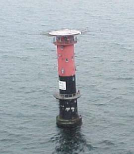
English: Fladen light, (57°13'N., 11°50'E.), equipped with a racon, is shown from a prominent floodlit tower, 26m high, standing on the NE side of Fladen, a sand bank with a least depth of 5.9 meters in teh Kattegat |
| التاريخ | |
| المصدر | http://www.nga.mil/portal/site/maritime/?epi_menuItemID=eb128c56b8e903e25b2a7fbd3227a759&epi_menuID=35ad5b8aabcefa1a0fc133443927a759&epi_baseMenuID=e106a3b5e50edce1fec24fd73927a759 Sailing Directions Enroute, Vol. 193, page 95 |
| المؤلف | NGA |
ترخيص
This image is a work of the United States National Geospatial-Intelligence Agency or one of its predecessor agencies. As a work of the U.S. federal government, the image is in the public domain.
|
 |
تاريخ الملف
اضغط على زمن/تاريخ لرؤية الملف كما بدا في هذا الزمن.
| زمن/تاريخ | صورة مصغرة | الأبعاد | مستخدم | تعليق | |
|---|---|---|---|---|---|
| حالي | 10:27، 13 أغسطس 2009 | | 270 × 312 (112 كيلوبايت) | commonswiki>Ratzer | {{Information |Description={{en|1=Fladen light, (57°13'N., 11°50'E.), equipped with a racon, is shown from a prominent floodlit tower, 26m high, standing on the NE side of Fladen, a sand bank with a least depth of 5.9 meters in teh Kattegat}} |Source=ht |
استخدام الملف
ال1 ملف التالي مكررات لهذا الملف (المزيد من التفاصيل):
- ملف:Fladen Light.PNG من ويكيميديا كومنز
الصفحة التالية تستخدم هذا الملف: