|
تضامنًا مع حق الشعب الفلسطيني |
ملف:African-civilizations-map-pre-colonial.svg

الملف الأصلي (ملف SVG، أبعاده 1٬390 × 1٬295 بكسل، حجم الملف: 488 كيلوبايت)
| هذا ملف من ويكيميديا كومنز. معلومات من صفحة وصفه مبينة في الأسفل. كومنز مستودع ملفات ميديا ذو رخصة حرة. |
محتويات
ملخص
| الوصفAfrican-civilizations-map-pre-colonial.svg |
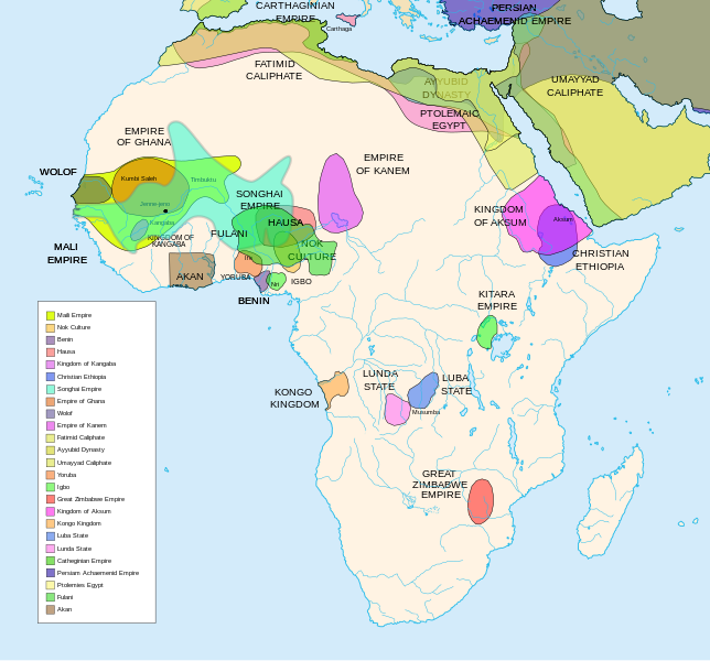
Africa History Atlas Diachronic map showing pre-colonial cultures of Africa (spanning roughly 500 BCE to 1500 CE) This map is "an artistic interpretation" using multiple and disparate sources. |
| التاريخ | |
| المصدر | عمل شخصي |
| المؤلف | Jeff Israel (ZyMOS) |
| إصدارات أخرى |
أَعمالٌ مُشتقَّة مِن هذا الملفِّ: African-civilizations-map-imperial.png
|
Civilizations
These civilizations are shown on the map above
Mali Empire (done):
        [4], [5], [6], [7], [8](1300), 14

Nok Culture(done):
        http://perso.orange.fr/miltiade/Civilisation_de_Nok.htm
        [5]

Fulani empire (aka sokoto empire, Sokoto Calphate, Fulani Empire of Sokoto)  (fulani people are different) (done):
        [2], [10e], [11e]
Akan States (generric term for states with the akan people)(Done):
 [7],
Benin: (done)
        [7],[14],[16]
Hausa (done)
        [7], [10],[16]

Kingdon of Kangaba (1000AD?) (done)
        [8](1235)

Christian Ethiopia(done)
        [5]

Songhai Empire (done)
        http://commons.wikimedia.org/wiki/Image:Mapa_shonghai.svg
        [3], [4], [5], [6], [7], [8](1300), [16]
        http://www.zum.de/whkmla/histatlas/westafrica/haxmali.html
        http://empathosnationenterprises.com/Consulate/EN-Library/Black-Studies/afempire.html

Empire of Ghana (done):
        [4], [5], [6], [7]

Wolof: (15th century) (done)
        [2],[2c],[14]

Empire of Kanem:(done)
        [15]

Fatimid caliphate(done) 909-1171AD
        [2b],[6b]

Ayyubid dynasty (done) 1171-1250ad
        [1b], [5e], [6e]

Umayyad Caliphate (done) 661-750
        [5b]

Yoruba yorubaland    (done)
        [4b],[2c]

Igbo    (done)
        [4b],

Great Zimbabwe (done):
        [5], [7]

Kingdom of aksum (Axum?) 1bc-7ad  (done)
        [12b],[14b],[15b]

Kongo Kingdom     (done)
        [1c], [2c],[15]

Luba State (done) 15-19th century
        [2c],[4c]

Lunda State (done) 15-19th century
        [2c],[4c],[16]

Carthaginian Empire(done) (220BCE) Carthage
        [2c], [3c]

Persian Achaemenid Empire (done)
        [2e],3e].4e],[

THE PTOLEMIES (done)
        [8e], [9e]
Civilizations to be added
These civilizations have not been added because the borders have not yet been confirmed, or there is some uncertainty if they are a true civilization. Please add them to the map if you are able to define the borders of these civilizations.
Mane (1000-2000)(city) [41]

Kano (independent city-state) (1000-1903):
 [14]

Kaarta (kingdom of Kaarta) (1753-1854):
 [14]

Macina (Macina Empire) (aka Dina of Massina, Sise Jihad state, and Caliphate of Hamdullahi) (1818-1862):
 [14]

Segou (city 1620):
 [14]

Kingdom of Fouta Djallon (Futa Djalon or Kingdom of Fuuta Jallon):
 [14]

Hausa Bakwai (initial stage Hausa):
 [11e]

Wassoulou Empire (Ouassoulou) (1878 - 1898) :
 [14]

Kénédougou Kingdom (Kenedougou) (1650-1898):
 [14]

Ouagadougou (15th century CITY):
 [14]

Ashanti Kingdom:
	[14]

Dahomey:
	[14]

Gando (16th century town):
	[14]

kingdom of Takrur (c. 800 - c. 1285) :
	[8](1300), [13]

Oyo empire (1400-1796)


Bornu Empire (1396-1893):
        [2],[15], [10e]

Bornu-Kanem (a portion of kanem history where they merged):
	[7],[2c]

Wodaabe (a people of africa):
	[10]

Mamluk Sultanate of Egypt (1174-1820):
	[2],[12],

Kush?Kushite kingdom?:

Axum (see kingdom of aksum):

Buganda kingdom (changed to Unganda, but remained as Buganda people):

Lozi???:

Malawi Empire (late 15th centure and converted to Malawi Contry):

Kilwa (Kilwa Kisiwani, 9th century,  is an Islamic community is present day tanzania):
	[2c]

Abyssinia???:
        [2], [7]

Soha????:
        [2],

Nubia (Makuria, Nobatia, Alodia kingdom):
	[7],

Kingdom of Kerma(2500BC-1520BC):

=North Central=

Sahariano??:
	[1],

Maban????????:
        [1],

Fur(a people:
        [1],

Sudanes Central (language Central Sudanic):
        [1],

=East Central=

Sudanes Meridional???:
        [1],

Berta(language>:
        [1],

Kunama(a people):
        [1],

Komuz???instument:
        [1],

Aksumite Civilization
	[7b], [9b(maybey], [13b(aksum)]

Kingdom of Sheva???
	[8b]

Egypt
	[10b]

JolofEmpire (also called Dyolof or Wolof), wolof should be changed to this:
	[11b]


Meroe(city, capital of Kushitic Kingdom))
	[12b]

Bantu(ethnic group)
	[12b]

Khoisan(ethnic group)
	[12b]

Almoravid Empire
	[5c], [1f]

Monomotapa
	[2c],[16]

Lozi
	[2c]

Zulu Kingdom
	[2c]

Merina
	[2c]

Malawi
	[2c]

Rawanda
	[2c]

Buganada
	[2c]

Kazembe
	[4c]


Punt (3000BC-1000BC):
	location lost in time

D'mt (800BC-100BC):


Gudit (1000AD):

Zagwe Dynasty (1000-1268AD):
	[6e]

Solomonic dynasty (1270-1974AD)

Himyar:
	[1d]

Qataban:
	[1d]

Saba:
	[1d]

Hadhramaut:
	[1d]

Thutmoses 1
	[1e]

Ramesses II
	[1e]

Assurbanipal, empire of
	[7e]

Mbunda Kingdom
	[12e], [13e]
Editing this page and map
Suggestions before editing this map: Be sure to confirm it with multiple sources, and that it would be considered a true civilization. Also if you add to the map please name the layers and objects to keep it organized. A lot of the civilizations on this page do not have the times they existed. If this could be added it would be very beneficial. Then the map could be easily split into eras.
References
The original map came from
- Image:Africa map political-fr.svg, by Eric Gaba.
- some of the features where removed to simplify it.
- [1] http://www.proel.org/mundo/songhai.htm
- [2] http://afriquepluriel.ruwenzori.net/africa-atlas22.htm نسخة مؤرشفة في Wayback Machine
- [3] https://www.metmuseum.org/toah/hd/sghi/hd_sghi.htm
- [4] http://buckley6thgradehistory.pbwiki.com/AceWiki
- [5] "The Harper Atlas of World History", 1987, William Collins Son & Co Ltd, New York, pg131
- [6] https://www.ucalgary.ca/HIST/tutor/imageislam/westAfrica.gif
- [7] http://empathosnationenterprises.com/Consulate/EN-Library/Black-Studies/afempire.html
- [8] http://www.plu.edu/~allenjjj/img/The%20Mali%20Empire.jpg نسخة مؤرشفة في Wayback Machine
- [9] http://www.mythinglinks.org/afr~subsahara~HausaFulani.html
- [10] http://www.uiowa.edu/~africart/toc/countries/Niger.html
- [11] is [6b]
- [12] http://www.meitmuseum.org/toah/hd/maml/hd_maml.htm
- [13] http://www.uv.es/~ivorra/Historia/AEM/SigloXg.htm
- [14] http://www.zum.de/whkmla/histatlas/westafrica/haxmali.html
- [15] http://www.loyno.edu/~seduffy/MapImages/Africa1500-1800-display.jpg
- [16] http://www.flotte2.com/1800AD.htm نسخة مؤرشفة في Wayback Machine
- [1b] https://www.metmuseum.org/toah/hd/ayyu/hd_ayyu.htm
- [2b] https://www.metmuseum.org/toah/hd/fati/hd_fati.htm
- [3b] https://www.metmuseum.org/toah/hd/pave/hd_pave.htm
- [4b] https://www.metmuseum.org/toah/hd/pave/hd_pave.htm
- [5b] https://www.metmuseum.org/toah/hd/umay/hd_umay.htm
- [6b] http://countryturkmenistan.tripod.com/index.blog?from=20050708
- [7b] http://en.wikipedia.org/wiki/Image:LocationAksumiteEmpire.png
- [8b] http://www.imninalu.net/tribes2.htm نسخة مؤرشفة في Wayback Machine
- [9b] http://www.freewebs.com/eritrea2001/infocenter.htm
- [10b] http://www.iziko.org.za/sh/resources/egypt/history_new_kingdom.htm
- [11b] http://www.geocities.com/jbenhill/timeline.html
- [12b] http://p083.ezboard.com/Not-all-of-Africans-belong-to-Bantu-or-Negroid-race/fbalkansfrm57.showMessage?topicID=56.topic[وصلة مكسورة]
- [13b] http://www.homestead.com/wysinger/aksum.html
- [14b] http://news.asmarino.com/TomasMebrahtu/Images/Map_.jpg نسخة مؤرشفة في Wayback Machine
- [15b] http://en.wikipedia.org/wiki/Image:GDRT230.jpg
- [16b] http://www.bible.ca/islam/islam-aksum-map-0-700ad.jpg
- [1c] https://www.metmuseum.org/toah/hd/acko/acko_d1map.htm
- [2c] http://exploringafrica.matrix.msu.edu/teachers/curriculum/m7b/activity1.php نسخة مؤرشفة في Wayback Machine
- [3c] http://www.livius.org/cao-caz/carthage/carthage.html
- [4c] http://concise.britannica.com/ebc/article-9370655/Luba-Lunda-states[وصلة مكسورة]
- [5c] http://www.allempires.com/forum/forum_posts.asp?TID=6586&PN=1
- [1e] http://www.iziko.org.za/sh/resources/egypt/history_new_kingdom.htm
- [2e] http://commons.wikimedia.org/wiki/Image:Achaemenid_Empire.jpg
- [3e] http://commons.wikimedia.org/wiki/Image:Carte_empire_ach%C3%A9m%C3%A9nide.png
- [4e] http://commons.wikimedia.org/wiki/Image:Persian_empire_490bc.gif
- [5e] http://commons.wikimedia.org/wiki/Image:Ayyubids1189.png
- [6e] http://commons.wikimedia.org/wiki/Image:Ayyubid.png
- [7e] http://www.fortunecity.com/tatooine/acegarp/898/10000bc601.htm نسخة مؤرشفة في Wayback Machine
- [8e] http://www.transanatolie.com/English/Turkey/Anatolia/Hellens/hellens.htm
- [9e] http://www.unc.edu/awmc/downloads/aegyptusPtolSml.jpg نسخة مؤرشفة في Wayback Machine
- [10e] http://www.amanaonline.com/Sokoto/table_of_content.htm
- [11e] http://www.britannica.com/ebi/art-3910?articleTypeId=1
- [12e] http://commons.wikimedia.org/wiki/File:Mbunda_Kingdom_Map.png
- [13e] https://www.mbundakingdom.org/ نسخة مؤرشفة في Wayback Machine
- [1x] http://commons.wikimedia.org/wiki/Image:Africa_15.PNG
- [2x] http://commons.wikimedia.org/wiki/Image:Africa_13.PNG
ترخيص

|
يسمح نسخ وتوزيع و/أو تعديل هذه الوثيقة تحت شروط رخصة جنو للوثائق الحرة، الإصدار 1.2 أو أي إصدار لاحق تنشره مؤسسة البرمجيات الحرة؛ دون أقسام ثابتة ودون نصوص أغلفة أمامية ودون نصوص أغلفة خلفية. نسخة من الرخصة تم تضمينها في القسم المسمى GNU Free Documentation License.http://www.gnu.org/copyleft/fdl.htmlGFDLGNU Free Documentation Licensetruetrue |
- يحقُّ لك:
- مشاركة العمل – نسخ العمل وتوزيعه وبثُّه
- إعادة إنتاج العمل – تعديل العمل
- حسب الشروط التالية:
- نسب العمل إلى مُؤَلِّفه – يلزم نسب العمل إلى مُؤَلِّفه بشكل مناسب وتوفير رابط للرخصة وتحديد ما إذا أجريت تغييرات. بالإمكان القيام بذلك بأية طريقة معقولة، ولكن ليس بأية طريقة تشير إلى أن المرخِّص يوافقك على الاستعمال.
- الإلزام بترخيص المُشتقات بالمثل – إذا أعدت إنتاج المواد أو غيرت فيها، فيلزم أن تنشر مساهماتك المُشتقَّة عن الأصل تحت ترخيص الأصل نفسه أو تحت ترخيص مُتوافِقٍ معه.
الشروحات
١ مايو 2007
image/svg+xml
458dcae2fb4eb4a66837ee9cd5c1e539750e7c18
٤٩٨٬٧٧٥ بايت
١٬٢٩٥ بكسل
١٬٣٩٠ بكسل
تاريخ الملف
اضغط على زمن/تاريخ لرؤية الملف كما بدا في هذا الزمن.
| زمن/تاريخ | صورة مصغرة | الأبعاد | مستخدم | تعليق | |
|---|---|---|---|---|---|
| حالي | 10:49، 16 فبراير 2024 |  | 1٬390 × 1٬295 (488 كيلوبايت) | commonswiki>Ahiise2 | Changed "Bachwezi Empire" to "Kitara Empire" to be consistent with other versions of the file |
استخدام الملف
ال1 ملف التالي مكررات لهذا الملف (المزيد من التفاصيل):
- ملف:African-civilizations-map-pre-colonial.svg من ويكيميديا كومنز
ال3 صفحات التالية تستخدم هذا الملف:
بيانات وصفية
هذا الملف يحتوي على معلومات إضافية، غالبا ما تكون أضيفت من قبل الكاميرا الرقمية أو الماسح الضوئي المستخدم في إنشاء الملف.
إذا كان الملف قد عدل عن حالته الأصلية، فبعض التفاصيل قد لا تعبر عن الملف المعدل.
| العرض | 1390 |
|---|---|
| الارتفاع | 1295 |


