|
تضامنًا مع حق الشعب الفلسطيني |
ملف:1794 Samuel Dunn Wall Map of the World in Hemispheres - Geographicus - World2-dunn-1794.jpg

الملف الأصلي (6٬000 × 5٬054 بكسل حجم الملف: 8٫92 ميجابايت، نوع MIME: image/jpeg)
| هذا ملف من ويكيميديا كومنز. معلومات من صفحة وصفه مبينة في الأسفل. كومنز مستودع ملفات ميديا ذو رخصة حرة. |
ملخص
| العنوان |
A General Map of the World, or Terraqueous Globe with all the New Discoveries and Marginal Delineations, Containing the Most Interesting Particulars in the Solar, Starry and Mundane System. |
||
| الوصف |
العربية: خريطة العالم رسم عالم الرياضيَّات البريطاني صموئيل دان، تعود إلى سنة 1794 م.
Български: Карта на света от британския математик Самюел Дан, 1794 г. Включва и карта на Луната, Слънчевата система и друга информация.
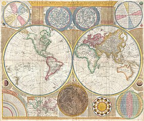
English: An absolutely stunning and monumental double hemisphere wall map of the world by Samuel Dunn dating to 1794. This extraordinary map is so large and so rich in detail that it is exceptionally challenging to do it full justice in either photographic or textual descriptions. Covers the entire world in a double hemisphere projection. The primary map is surrounded on all sides but detailed scientific calculations and descriptions as well as northern and southern hemisphere star charts, a map of the Moon, a Latitude and Longitude Analemma chart, a map of the Solar System, a Mercator projection of the world, an Analemma projection, a seasonal chart, a universal scale chart, and numerous smaller diagrams depicting planets and mathematical systems. All text is in English. We will start our survey of this map in North America, much of which was, even in 1794, largely unknown. This map follows shortly after the explorations of Captain Cook in the Arctic and Pacific Northwest, so the general outline of the continent is known. However, when this map was made, few inland expeditions had extended westward beyond the Mississippi. This map notes two separate speculative courses for the apocryphal River of the West, a northern route extending from Lake Winnipeg and a southern route passing south of Winnepeg through Pike's lake. The River of the West was hopeful dream of French and English explorers who were searching for a water passage through North America to the Pacific. In concept, should such a route be found, it would have become an important trade artery allowing the British and French, who's colonies dominated the eastern parts of North America, to compete with the Spanish for control of the lucrative Asia-Pacific trade. Little did these earlier speculative cartographers realize the bulk of the Rocky Mountains stood between them and their dreams! Slightly south of the Rivers of the West, we find the kingdom of Quivira, which is one of the lands associated with Spanish legends of the Seven Cities of Gold. In this area we can also find Drake's Harbor or Port de la Bodega and Albion. Drake's Harbor is where Sir Francis Drake supposedly landed during his circumnavigation of the globe in 1580. Drake wintered in this harbor and used the abundant resources of the region to repair his ships. He also claimed the lands for England dubbing them New Albion. Although the true location of Drake's port is unknown, most place it much further to the north. By situating it and consequently New Albion further to the south, Dunn is advocating a British rather than Spanish claim to this region. On the Eastern coast of North America we find a fledgling United States extending from Georgia to Maine. Dunn names Boston, New York, Charleston, Long Island, and Philadelphia, as well as the important smaller towns of Jamestown, Williamsburg and Edonton. South America exhibits a typically accurate coastline and limited knowledge of the interior beyond Peru and the populated coastlands. A few islands are noted off the coast, including the Galapagos, which are referred to as the Inchanted Islands. The Amazon is vague with many of its tributaries drawn in speculatively. Dunn and d'Anville have done away with the popular representation of Manoa or El Dorado in Guyana, but a vestigial Lake Parima is evident. Further south, the Laguna de los Xarayes, another apocryphal destination, is drawn at the northernmost terminus of the Paraguay River. The Xaraiés, meaning Masters of the River were an indigenous people occupying what are today parts of Brazil's Matte Grosso and the Pantanal. When Spanish and Portuguese explorers first navigated up the Paraguay River, as always in search of El Dorado, they encountered the vast Pantanal flood plain at the height of its annual inundation. Understandably misinterpreting the flood plain as a gigantic inland sea, they named it after the local inhabitants, the Xaraies.
Español: Mapamundi, elaborado por Samuel Dunn en 1794, que incluye los hemisferios oriental y occidental, asi como un mapa del sistema solar y un mapa lunar, entre otros.
Українська: Настінна карта світу з подвійною півсферою Семюеля Данна, датована 1794 роком. |
||
| التاريخ | (dated) | ||
| المصدر |
Kitchin, Thomas, Kitchin's General Atlas, describing the Whole Universe: being a complete collection of the most approved maps extant; corrected with the greatest care, and augmented from the last edition of D'Anville and Robert with many improvements by other eminent geographers, engraved on Sixty-Two plates, comprising Thirty Seven maps., Laurie & Whittle, London, 1797.
|
||
| الصانع | |||
| Georeferencing | If inappropriate please set warp_status = skip to hide. | ||
| Archival data | |||
| رقم التصنيف |
وصلة موقع جيوغرافيكوس: World2-dunn-1794 |
||
| الأبعاد | ارتفاع: ٤٢٫٠ إنش (١٠٦٫٦ سم)؛ عرض: ٤٩٫٠ إنش (١٢٤٫٤ سم) | ||
التقييم
|
اختيرت هذه الصُّورة لتكون صورة اليوم في ويكيميديا كُومِنز بتاريخ 28 March 2022. كان التَّعليق المُرفَق معها كما يأتي: English: An absolutely stunning and monumental double hemisphere wall map of the world by Samuel Dunn dating back to 1794 بلغاتٍ أُخرى:
Čeština: Mimořádně dokonalá a monumentální nástěnná mapa obou polokoulí světa britského matematika Samuela Dunna z roku 1794. Deutsch: Weltkarte in zwei Hemisphären von Samuel Dunn aus dem Jahr 1794. English: An absolutely stunning and monumental double hemisphere wall map of the world by Samuel Dunn dating back to 1794 Español: Mapamundi elaborado por Samuel Dunn en 1794, que incluye los hemisferios oriental y occidental, asi como un mapa del sistema solar y un mapa lunar, entre otros. Français : Une carte du monde à double hémisphère réalisée en 1794 par Samuel Dunn, mathématicien et cartographe britannique. Très détaillée pour l'époque, elle contient également une carte du ciel (constellations), de la Lune et du Système solaire. Magyar: Samuel Dunn által 1794-ben készített világtérkép a keleti és a nyugati féltekével, a Naprendszer térképével, valamint egy holdtérképpel Nederlands: Wandkaart uit 1794 met onder meer het oostelijk en het westelijk halfrond, de Maan en de sterrenhemel Português: Mapa-múndi elaborado por Samuel Dunn em 1794, que inclui os hemisférios oriental e ocidental, assim como um mapa do sistema solar e um mapa lunar, entre outros. Авар: 1794 соналъ Сэмюэл Данница бахъараб дунялалъул ракьхъвай Македонски: Карта на двете Земјини полутопки од Семјуел Дан, 1794 г. Русский: Карта мира Сэмюэля Данна 1794 года Українська: Настінна карта світу з подвійною півсферою Семюеля Данна, датована 1794 роком. 中文: 絕對精確且巨大的雙半球體壁掛世界地圖,由 Samuel Dunn 於1794年繪製 |
ترخيص
|
هذا العمل يقع في النَّطاق العامّ في بلد المنشأ وفي البلدان الأخرى والمناطق التي تمتدُّ فيها مدة حقوق التَّأليف والنشر لتغطي زمن حياة المُؤلِّف و 100 سنةً بعد وفاته أو أقل من ذلك. يقع هذ العمل في النَّطاق العامِّ في الولايات المُتحدة الأمريكيَّة لأنَّه نُشِرَ (أو سُجِّل لدى مكتب الولايات المُتحدة لحقوق التَّأليف والنَّشر) قبل ١ يناير ١٩٢٩. | |
| هذا الملفُّ مَلحُوظُ بصفته غيرَ مُقيَّدٍ بحقوق التَّأليف والنشر، وهذا يشمل أيضاً الحقوق المُجاوِرة أَو ذات الصلة جميعُها. | |
تاريخ الملف
اضغط على زمن/تاريخ لرؤية الملف كما بدا في هذا الزمن.
| زمن/تاريخ | صورة مصغرة | الأبعاد | مستخدم | تعليق | |
|---|---|---|---|---|---|
| حالي | 00:01، 2 يونيو 2012 | | 6٬000 × 5٬054 (8٫92 ميجابايت) | commonswiki>Brandmeister~commonswiki | Reverted to version as of 04:17, 23 March 2011 |
استخدام الملف
ال1 ملف التالي مكررات لهذا الملف (المزيد من التفاصيل):