|
تضامنًا مع حق الشعب الفلسطيني |
ملف:16th century Portuguese Spanish trade routes.png
اذهب إلى التنقل
اذهب إلى البحث

حجم هذه المعاينة: 800 × 335 بكسل. الأبعاد الأخرى: 320 × 134 بكسل | 640 × 268 بكسل | 1٬024 × 429 بكسل | 1٬280 × 536 بكسل | 2٬835 × 1٬188 بكسل.
الملف الأصلي (2٬835 × 1٬188 بكسل حجم الملف: 2 ميجابايت، نوع MIME: image/png)
| هذا ملف من ويكيميديا كومنز. معلومات من صفحة وصفه مبينة في الأسفل. كومنز مستودع ملفات ميديا ذو رخصة حرة. |
| الوصف |
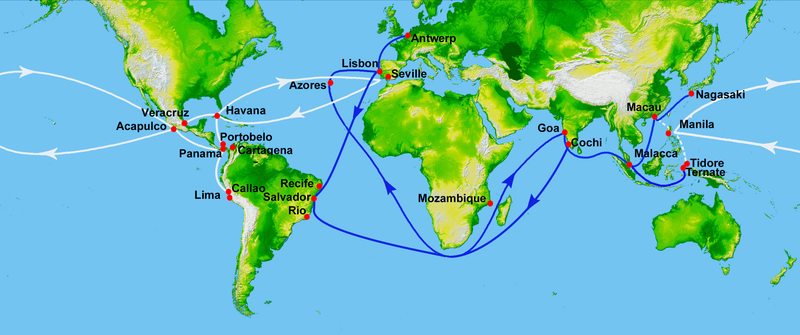
Map showing main Portuguese (blue) and Spanish (white) oceanic trade routes in the 16th century, as a result of the exploration during the Age of Discovery.
|
| التاريخ | (UTC) |
| المصدر | |
| المؤلف |
|
| هذا رسمٌ مُعَدَّلٌ رقميَّاً من النسخة الأصليَّة. التعديلات هي: depiction of 16th century Portuguese and Spanish trade routes. يُمكن الاطلاع على النسخة الأصليَّة هنا: World Topography.jpg:
|
This image uses high-resolution digital topography data from NASA's Shuttle Radar Topography Mission (SRTM) at JPL-Caltech [1]. It is in the public domain in the United States.
|
 | |
سجلُّ الرَّفع الأصيل
This image is a derivative work of the following images:
- File:World_Topography.jpg licensed with PD-USGov-NASA-SRTM
- 2009-03-17T12:12:25Z Sk 21600x9049 (17145460 Bytes) {{Information |Description=PIA03395: World in Mercator Projection, Shaded Relief and Colored Height |Source=http://photojournal.jpl.nasa.gov/catalog/PIA03395 |Date=February 2000 |Author=NASA/JPL/NIMA |Permission={{PD-USGov-
Uploaded with derivativeFX
تاريخ الملف
اضغط على زمن/تاريخ لرؤية الملف كما بدا في هذا الزمن.
| زمن/تاريخ | صورة مصغرة | الأبعاد | مستخدم | تعليق | |
|---|---|---|---|---|---|
| حالي | 03:50، 16 يوليو 2023 | | 2٬835 × 1٬188 (2 ميجابايت) | commonswiki>Hohum | Brighten |
استخدام الملف
ال1 ملف التالي مكررات لهذا الملف (المزيد من التفاصيل):
- ملف:16th century Portuguese Spanish trade routes.png من ويكيميديا كومنز
الصفحتان التاليتان تستخدمان هذا الملف: